


Mapit GIS - Map Data Collector


Mapit GIS - Map Data Collector leírása
A Mapit egy professzionális, önálló, költséghatékony térképezési és felmérési eszköz, melynek célja a termelékenység növelése, miközben ott tartózkodik a területen.
Az alkalmazás támogatja a gyakori fájlformátumokat a bemenetek és kimenetek számára, és képes együttműködni számos külső GNSS vevőkészülékkel, így centiméteres pontosságot kaphat, amikor szükséges.
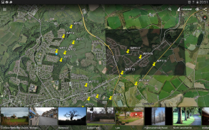
Tervezze meg a felmérési űrlapokat, szervezzen adatokat a rétegeken, dolgozzon offline-ban az mbtiles bázis térképekkel, használja a WMS szolgáltatásokat, használja a GPS nyomkövetést, hogy rögzítse a vonal- és sokszög funkciókat, rögzítse a GNSS metaadatait és még sok más felfedezésre.
Az alkalmazást világszerte széles körben használják a szakemberek, és könnyen alkalmazhatók a mezőgazdaság és az erdőgazdálkodás és az útépítés, a geológia, a földmérés és a napelemes megoldások számára. A személyre szabott beállítások és a rugalmasság teszi ezt az alkalmazást célszerszámnak, amely fokozza a felmérési munkafolyamatot.
Az alkalmazás mérési eszközként is használható a területek vagy távolságok kiszámításához.
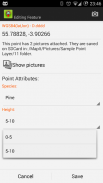
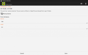
Ha helyet takarít meg, egyszerűen válassza ki a kívánt attribútumokat az előre meghatározott legördülő listából, nem kell újra és újra beírni ugyanezt az információt. A szövegfájlokból származó attribútumok hosszú listáját importálhatja és újra felhasználhatja több projektben. Ha szükséges, képeket is hozzáadhat az egyes helyekhez is.
Ha a területen dolgozol, nagy mennyiségű téradatot gyűjthetsz, ez az alkalmazás az Ön számára készült.
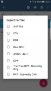
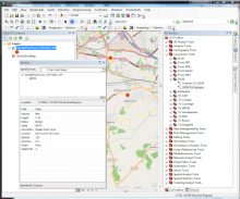
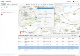
Gyorsítsa a munkafolyamatot, és hatékonyabbá teszi az adatgyűjtést. Használja ki a felmérési rétegek előnyeit és a lehetőséget arra, hogy ugyanazon attribútumkészletet újra felhasználhassa többszörös felmérésekhez. Exportálja az adatait a közös GIS formátumokra, mint például az Esri formátumformátum, a CSV, a KML, a geojson, a DXF, a GPX és az adatok feldolgozása az asztali GIS szoftver, például a qGIS segítségével.
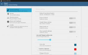
Szükség esetén az előre meghatározott koordinátarendszerek és az egyéni EPSG-kódok támogatása.
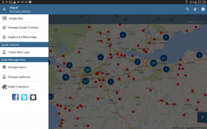
Mobil adatgyűjtési szolgáltatások:
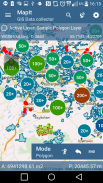
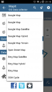
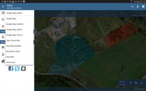
- Bázis térképek: Népszerű online térképek és offline meccsek
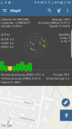
- Az RTK korrigált koordináták támogatása, ha külső Bluetooth GPS / GNSS van csatlakoztatva,
- A WMS és a GIS kiszolgáló csempézett térképszolgáltatások támogatása - topográfiai és ortofotós térképek, geológiai felmérések, kataszteri információk és egyéb szolgáltatások száma.
- Lehetőség attribútumkészletek létrehozására és karbantartására - ezek az új funkció rögzítésekor legördülő listákként érhetők el, hosszú értékek listája importálható szövegfájlokból.
- Pont-térképjelzők klaszterei, hatékony módja annak, hogy nagy számú pontot kapjon a térképen teljesítménykérdések nélkül,
- Jelenleg 4 gyűjtési módszert támogatnak (GPS / GNSS hely, térkép kurzor helye, követés, pont vetítés szög és távolság alapján),
- Az adatok csoportosítása a felmérési rétegekre - minden felmérési réteg alapértelmezett attribútumkészletet tartalmazhat.
- Helyi SD-kártya vagy távoli exportálás. Jelenleg a shapefiles, a KML, a CSV, a geojson, a GPX és a DXF export támogatott,
- Közvetlen exportálás a Dropboxba vagy az FTP helyre
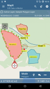
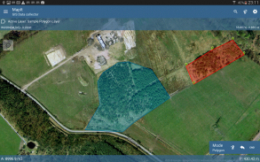
- Lehetőség több pont, vonal és sokszög rögzítésére egy rétegre,
- Új poligon vagy vonaltulajdonságok létrehozásakor a mérési részletek, például a terület vagy a hosszúság is elérhetőek.
- GPS / GNSS és műholdak állapota,
- cím, hely keresés,
- A pont, vonal és sokszög funkciók importálása CSV, KML, shapefile vagy geojson fájlból,
- Biztonsági mentés,
- Import / Export attribútumok a fájlból, és még sok más a felfedezéshez ...
Felhasználóink sikeresen használják a Mapit-ot számos alkalmazásban, beleértve:
- Környezeti és erdészeti felmérések, \ t
- Erdészeti tervezés és erdőgazdálkodás, \ t
- Mezőgazdasági és talajosztályozás és mintavétel, \ t
- Útépítés,
- Földmérés,
- Napelemes alkalmazások,
- Tetőfedés és kerítés,
- Fafelmérések,
- GPS és GNSS felmérés,
- Helyszíni felmérés
- Hóeltakarítás
Ne habozzon kapcsolatba lépni velünk közvetlenül vagy a honlapunkon található kapcsolati űrlapon.
Mapit GIS - Map Data Collector - 7.8.0.0Core verzió
(16-08-2021)

Mapit GIS - Map Data Collector - APK információ
APK verzió: 7.8.0.0CoreCsomag: com.osedok.gisdatacollectorMapit GIS - Map Data Collector legújabb verziója
Egyéb változatok


Appok ebben a kategóriában

Ami még tetszhet...


